My family and I spent a wonderful summer vacation week two years ago on Lake Lure in North Carolina. With two sporty golf courses, pools, a few fine restaurants and, of course, all the customary activities of a tourist-attractive lake, it was a great place for a holiday and, given the number of enthusiastic retirees I met, to live full time. Lake Lure is a magnet for family vacations during the summer months. Much of the film Dirty Dancing was filmed alongside the lake.
Paradise has been lost, at least for this weekend, in the aftermath of Hurricane Helene, as the dam guarding the lake was breached on Friday, with two feet of water spilling over the entire top of the dam and water flowing around its sides. At first local officials issued a dire warning that the dam might collapse but, glad to say, it held fast. The eponymous Lake Lure Dam opened in 1927, when a local developer decided to turn the area around the lake into a playground for the wealthy. Bad timing, however, with the Great Depression just two years away.
Lake Lure today appeals to an economically diverse population and features homes priced from the $300s (condos and townhomes) to the millions for lavish single-family estate homes. (We rented one for our vacation which was located high on one of the surrounding mountains inside the Rumbling Bald Resort. Other single homes inside Rumbling Bald start in the $400s.) The news from Lake Lure, which is not customarily threatened by extreme weather, reminds us that few places on the map are immune from bad weather. From hurricanes in the South to tornados in the Midwest and South, to extreme heat in the Southwest and wildfires in California, a retirement or vacation dream home can become a nightmare at the drop of a Weather Channel warning. For their due diligence, home buyers should include bad weather risks in their assessments of locations they have targeted.
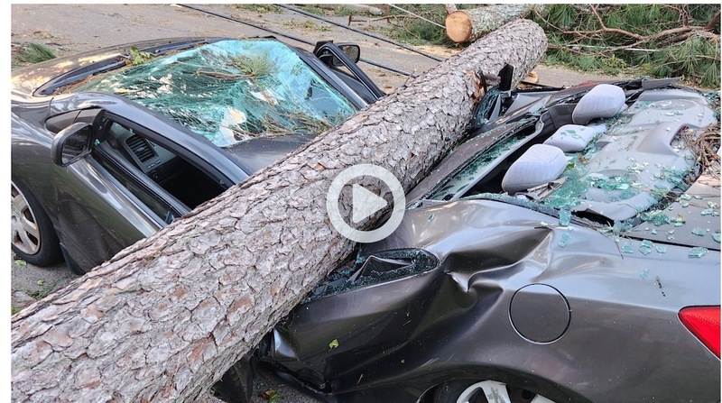
 A crushed car in Western North Carolina caused by winds and flooding from Hurricane Helene. The photo was taken from a video posted by local TV station ABC11.
For my own research, I have used a site managed by First Steet Financial called RiskFactor.com. First Street uses government data on climate events to predict the potential risks for virtually every address in the nation. Started as FloodFactor.com, the site now assesses all the major threat potentials from floods, wind, heat, fire and air (the later based on pollution and any toxic materials in the area). The initial stories I wrote about the biggest threat to golf communities in the Southeast were focused on properties near the Atlantic Ocean and Gulf coast, such as the near-ocean South Carolina vacation condo my wife and I have owned since 2000. The articles were all about the devastating effects of water surge and winds produced by hurricanes. But more and more, we are learning that devastation does not end on the shores of Florida or the Carolinas, but can wreak almost as much havoc hundreds, and occasionally thousands, of miles away.
Besides Lake Lure, many locations in Asheville and western North Carolina are under water. In a report on a local TV station, one emergency services official for surrounding Buncombe County said: "This is the most significant natural disaster that any one of us has ever seen in western North Carolina." In and around Asheville, local rescuers removed more than 50 people from fast-rising and swiftly moving waters. More than 400 roads in the state were closed on Friday. “All roads in western North Carolina should be considered closed,” the NC Department of Transportation reported. (The area of western North Carolina is 10 times the size of the entire state of Rhode Island.) Scenes of destruction on local news videos – reminiscent of the aftermaths of direct hits from hurricanes – did immense damage in an area that is more than half a mile above sea level (at 2,134 feet). This local news report that includes some riveting scenes of destruction. Click here.
Elsewhere, Helene’s aftermath was equally devastating. In Augusta, GA, where 14 people died in what is known at the Central Savannah River Area (CSRA), the Augusta National Golf Club, host to the Master, said it was “assessing the effects” on the golf course and club but its thoughts were with the local community. Downed power lines and flooding caused local officials in Augusta and surrounding counties to order overnight curfews. It is becoming clearer that communities far from hurricane landfall are not immune from the after-affects.
If you are worried about the potential risk to a property you own, or are considering purchase of one, especially in the most vulnerable areas, RiskFactor.com will provide you with one free report. (After that, you can subscribe for a fee if you want.) Zillow.com recently announced it will begin to include risk factors in its listings, in a partnership with First Street Financial. Whether Zillow will include those risk factors for all homes, not just those listed for sale, is not clear yet, but for those contemplating a move south to a golf community, I suggest you find a home for sale in the community, plug its address into Zillow and see, if as promised, the listing includes its risk factors. Keep in mind, though, that Risk Factor is a predictive model; it advises about the “potential” for a major flood or other event over a 30-year period. That means you could be hit in 30 years or it might happen next year – either way in a location that seems relatively safe at the moment. Risk Factor shows some of the golf community addresses in affected areas in western North Carolina as being at a “minor risk” level. For thousands in that part of the state, minor is now major -- and that 30-year closed tight immediately.
*
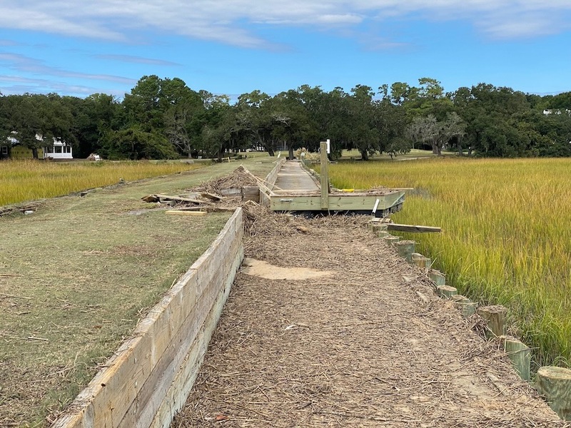
 The aftereffects of Hurricane Ian, which crossed Florida and reformed off the coast of South Carolina, sported winds and a storm surge strong enough to lift docks and boats and deposit them onto the Pawleys Plantation golf course, a half mile away. This is the dike that runs between the 13th and 17th tee boxes.
My wife's and my condo in Pawleys Island, SC, is a six-minute drive to the Atlantic Ocean beach, but just about ¾ of a mile as the gull flies across the marsh. In the nearly 25 years we have owned our condo, it has not suffered any flooding whatsoever. Three years ago, when I last checked, our “flood factor” rating was a modest 3, meaning a “moderate” level of risk over the next 30 years. But today, the rating is a 6 which indicates a “major” level of risk. Sea levels are rising and hurricanes appear to be more intense. I am sure First Street Financial is factoring that into its calculations.
A decade before we bought the condo, Hurricane Hugo, the most severe hurricane to affect Pawleys Island in the last 50 years, made landfall in the Charleston area, about 60 miles south, but its winds and storm surged lifted and destroyed 50 homes out on the island. Pawleys Plantation, our community, had recently opened, and there was a smattering of homes already built on site. The Jack Nicklaus golf course had recently opened. According to reports, many trees were downed along the golf course and, of course, the fairways and greens took on a lot of water for a while. Salt water, which flooded the course from the adjacent marsh, is not friendly to golf greens especially. But the golf course, local people have told me, survived quite well with only limited damage. (I played it a few months after the storm, and it looked fine.) Our only on-the-scene knowledge of a hurricane’s effect on our community was actually a tropical storm precipitated by Hurricane Ian in 2022, which barreled across Florida, reconstituted off the South Carolina shore, and made landfall (again) just south of Pawleys Island. Although the winds were just short of hurricane category at around 80 mph, the storm surge was impressive enough to dump a few feet of sand from the beach that covered the island’s roads, and to lift and deposit pieces of boat docks, and a few boats themselves, on our golf course, about a half mile inland. Although a relatively mild storm, it gave a hint of the devastation a Category 3 or higher would wreak.


